


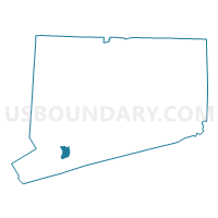
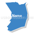
Bridgeport Town PUMA, Connecticut
About
Outline

Summary
| Unique Area Identifier | 192504 |
| Name | Bridgeport Town PUMA |
| State | Connecticut |
| Area (square miles) | 19.34 |
| Land Area (square miles) | 15.97 |
| Water Area (square miles) | 3.37 |
| % of Land Area | 82.59 |
| % of Water Area | 17.41 |
| Latitude of the Internal Point | 41.18738580 |
| Longtitude of the Internal Point | -73.19573390 |
Maps
Graphs
Select a template below for downloading or customizing gragh for Bridgeport Town PUMA, Connecticut


Neighbors
Neighoring Public Use Microdata Area (by Name) Neighboring Public Use Microdata Area on the Map
- Fairfield, New Canaan, Wilton, Weston & Easton Towns PUMA, CT
- Norwalk, Westport & Darien Towns PUMA, CT
- Stratford, Shelton, Trumbull, Newtown & Monroe Towns PUMA, CT
Top 10 Neighboring County (by Population) Neighboring County on the Map
Top 10 Neighboring County Subdivision (by Population) Neighboring County Subdivision on the Map
- Bridgeport town, Fairfield County, CT (144,229)
- Fairfield town, Fairfield County, CT (59,404)
- Stratford town, Fairfield County, CT (51,384)
- Trumbull town, Fairfield County, CT (36,018)
- County subdivisions not defined, Fairfield County, CT (0)
Top 10 Neighboring Place (by Population) Neighboring Place on the Map
Top 10 Neighboring Unified School District (by Population) Neighboring Unified School District on the Map
- Bridgeport School District, CT (144,229)
- Fairfield School District, CT (59,404)
- Stratford School District, CT (51,384)
- Trumbull School District, CT (36,018)
- School District Not Defined (Water), CT (0)
Top 10 Neighboring State Legislative District Lower Chamber (by Population) Neighboring State Legislative District Lower Chamber on the Map
- State House District 123, CT (24,985)
- State House District 127, CT (24,726)
- State House District 126, CT (24,578)
- State House District 133, CT (24,556)
- State House District 129, CT (24,361)
- State House District 132, CT (24,317)
- State House District 124, CT (23,959)
- State House District 134, CT (23,832)
- State House District 130, CT (23,767)
- State House District 121, CT (22,957)
Top 10 Neighboring State Legislative District Upper Chamber (by Population) Neighboring State Legislative District Upper Chamber on the Map
- State Senate District 28, CT (103,194)
- State Senate District 22, CT (101,713)
- State Senate District 21, CT (96,683)
- State Senate District 23, CT (95,642)
- State Senate Districts not defined, CT (0)
Top 10 Neighboring 111th Congressional District (by Population) Neighboring 111th Congressional District on the Map
Top 10 Neighboring Census Tract (by Population) Neighboring Census Tract on the Map
- Census Tract 726, Fairfield County, CT (7,583)
- Census Tract 904, Fairfield County, CT (6,552)
- Census Tract 721, Fairfield County, CT (6,094)
- Census Tract 804, Fairfield County, CT (5,956)
- Census Tract 731, Fairfield County, CT (5,853)
- Census Tract 725, Fairfield County, CT (5,726)
- Census Tract 728, Fairfield County, CT (5,469)
- Census Tract 723, Fairfield County, CT (5,396)
- Census Tract 712, Fairfield County, CT (5,205)
- Census Tract 701, Fairfield County, CT (5,021)
Top 10 Neighboring 5-Digit ZIP Code Tabulation Area (by Population) Neighboring 5-Digit ZIP Code Tabulation Area on the Map
- 06606, CT (46,236)
- 06611, CT (36,091)
- 06824, CT (33,900)
- 06614, CT (32,929)
- 06604, CT (30,313)
- 06605, CT (23,397)
- 06610, CT (22,735)
- 06825, CT (21,123)
- 06615, CT (18,453)
- 06608, CT (13,671)